
Rain swells waterways; winter storm imminent
Dale Hollow Lake rises nine feet in a week
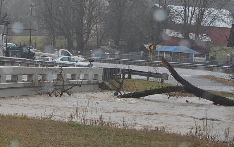
CLAY COUNTY-Waterways across the county swelled after an average of eight inches of rain fell here last week across the region, widespread flash flooding was also reported, and the second significant winter storm of the season was imminent as of HORIZON press time Monday.
A total of 7.97 inches of rain was recorded in Celina by local Community Collaborative Rain, Hail and Snow network (CoCoRaHS) weather observer Kevin Donaldson for a weeklong period extending through Sunday.
Over the same time period, 8.48” was recorded near Red Boiling Springs and 7.23 inches near Allons by other CoCoRaHS observers here in the county.
Flooded roadways were reported both by the City of Celina and the Clay County Sheriff’s Office on social media as a result.
“We have received many reports throughout the morning about many flooded and impassable roads throughout the county,” the local sheriff said in a Facebook post, which also listed flooded roadways Saturday morning.
City mayor Luke Collins also used the city’s Facebook account to alert locals.
“The City of Celina urges motorists to use caution while traveling down the flooded roadways in town,” the post said.
Besides flash flooding issues, the weeklong deluge with two 24-hour periods where close to 2.5 inches fell here also spiked elevation levels on Dale Hollow Lake.
When 2.42 inches were recorded by Donaldson on February 11, the lake steadily rose three feet—from around 641 feet above sea level (FASL) to 644 FASL.
A 48-hour span from February 15-16 where a total of 4.19 inches of rain fell in Celina then caused the reservoir to rise six more feet as of Monday, when a lake level of near 650 FASL was seen.
With the local like rising a total of nine feet in elevation and other area waterways bursting at the seams, the U.S. Army Corps of Engineers (Corps) activated their Level 1 response, where they worked around the clock monitoring conditions, adjusting dam operations, and coordinating with emergency agencies to reduce flood risks.
While the Corps and the Tennessee Valley Authority (TVA) worked in unison to allow water to flow through the Cumberland River Basin and the Tennessee River with water releases, none were seen at Dale Hollow Lake, Center Hill Lake, and Lake Cumberland, causing all three to rise drastically.
The three area lakes were used for flood control and had no releases through Sunday to limit downstream flooding, according to a Corps news release.
Dale Hollow Dam began releases with “two or more” generators at an average hourly discharge of 3,625 cubic feet per second Monday.
Predicted data online at tva.com showed 24/7 generation was projected to continue Tuesday and Wednesday.
The heavy generation was set to allow the lake’s elevation to peak at around 650.50 FASL and begin to fall just in time for more precipitation to come.
This time, with colder temperatures in place, as much as four inches of snow was forecast for the area and a winter storm warning had been issued for Clay County Monday afternoon.
The warning was to go into effect at 9 p.m. Tuesday and continue through noon Wednesday.
It said “heavy snow” with “total snow accumulations between 3 and 4 inches” was expected.
“Roads, and especially bridges and overpasses, will likely become slick and hazardous,” the warning said. “The hazardous conditions could impact the Wednesday morning commute.”
To keep up with this week’s winter storm and for other local weather information, follow Donaldson on Facebook and X, along with the HORIZON’s Facebook page.